地址: 800 (From 800 To 898 Even) N ST, ANCHORAGE, AK 99501-3229, USA
99501-3229是什么? 99501-3229是 800 (From 800 To 898 Even) N ST, ANCHORAGE, AK, USA的5加4位邮编。下面是详细信息。
99501-3229基本信息

-
邮政编码5加4:
99501-3229 -
邮政编码5:
99501 -
加4?32294-digits that are used to identify a geographic segment within the 5-digit delivery area, such as a city block or a group of apartments or an individual high-volume receiver of mail, or any other unit that could use an extra identifier to aid in efficient mail sorting and delivery. This code is the low end of the range of +4 Codes that pertain to this ZIP Code. ZIP+4 Codes associated with nondelivery areas are composed of valid ZIP sector numbers and "ND" for the ZIP segment number, for example 12345-12ND. Non-deliverable areas are areas to which the USPS does not deliver mail, such as vacant lots and land that borders railroad tracks. Mailers should not match an address identified as a nondelivery area. If you absolutely must have numeric characters in the Plus4Code column, you may treat "ND" values as "00" (zero zero).:
-
国家:
U.S. - 美国 -
州:
AK - 阿拉斯加州 -
区县:
CountyFIPS: 02020 - Anchorage Municipality -
城市:
ANCHORAGE -
街道?N STThe official name of a street as assigned by a local governing authority. The Street Name column contains only the street name and does not include directionals (EAST, WEST, etc.) or suffixes (ST, DR, BLVD, etc.). This element may also contain literals, such as PO BOX, GENERAL DELIVERY, USS, PSC, or UNIT. Numeric street names that have numeric components that are four characters (or less) in length at are justified such that the low-order digit of the number is positioned in the fourth position of the street name column. This shift is made so that the numeric street names appear in numeric sequence.:
-
街道后缀?ST (街道)The street suffix: For Example: ST = Street RD = Road DR = Drive LN = Lane:
-
记录类型?S: 街道An alphabetic value that identifies the type of data in the record. Record type codes include the following: G = General delivery H = Highrise F = Firm S = Street P = PO box R = Rural route/highway contract:
地址

- 主要地址低位数字?
A house, rural route, highway contract box, or post office box number; the numeric or alphanumeric component of an address preceding the street name; the low-end address in a range of addresses. Often referred to as house number.: 800
- 主要地址高位数字?
A house, rural route, contract box, or Post Office box number. The numeric or alphanumeric component of an address preceding the street name. The high-end address in a range of addresses. Often referred to as house number.: 898
- 主要地址奇/偶码?
Code that identifies the side or sides of a street for which a given address range is applicable. For street, highrise, firm and multi-carrier records, B = Both sides of a street, E = Even side of a street (even-numbered addresses in the range); O = Odd side of a street (odd-numbered addresses in the range). For general delivery, post office box, and rural route/highway contract records, this code will always be "B" (both).: Even
- 主要范围: 800, 802, 804, 806, 808, 810, 812, 814, 816, 818, 820, 822, 824, 826, 828, 830, 832, 834, 836, 838, 840, 842, 844, 846, 848, 850, 852, 854, 856, 858, 860, 862, 864, 866, 868, 870, 872, 874, 876, 878, 880, 882, 884, 886, 888, 890, 892, 894, 896, 898.
请单击"更多地址示例"查看整个列表。
800 N ST, ANCHORAGE, AK 99501-3229
802 N ST, ANCHORAGE, AK 99501-3229
804 N ST, ANCHORAGE, AK 99501-3229
806 N ST, ANCHORAGE, AK 99501-3229
808 N ST, ANCHORAGE, AK 99501-3229
810 N ST, ANCHORAGE, AK 99501-3229
812 N ST, ANCHORAGE, AK 99501-3229
814 N ST, ANCHORAGE, AK 99501-3229
816 N ST, ANCHORAGE, AK 99501-3229
818 N ST, ANCHORAGE, AK 99501-3229
820 N ST, ANCHORAGE, AK 99501-3229
822 N ST, ANCHORAGE, AK 99501-3229
824 N ST, ANCHORAGE, AK 99501-3229
826 N ST, ANCHORAGE, AK 99501-3229
828 N ST, ANCHORAGE, AK 99501-3229
830 N ST, ANCHORAGE, AK 99501-3229
832 N ST, ANCHORAGE, AK 99501-3229
834 N ST, ANCHORAGE, AK 99501-3229
836 N ST, ANCHORAGE, AK 99501-3229
838 N ST, ANCHORAGE, AK 99501-3229
840 N ST, ANCHORAGE, AK 99501-3229
842 N ST, ANCHORAGE, AK 99501-3229
844 N ST, ANCHORAGE, AK 99501-3229
846 N ST, ANCHORAGE, AK 99501-3229
848 N ST, ANCHORAGE, AK 99501-3229
850 N ST, ANCHORAGE, AK 99501-3229
852 N ST, ANCHORAGE, AK 99501-3229
854 N ST, ANCHORAGE, AK 99501-3229
856 N ST, ANCHORAGE, AK 99501-3229
858 N ST, ANCHORAGE, AK 99501-3229
860 N ST, ANCHORAGE, AK 99501-3229
862 N ST, ANCHORAGE, AK 99501-3229
864 N ST, ANCHORAGE, AK 99501-3229
866 N ST, ANCHORAGE, AK 99501-3229
868 N ST, ANCHORAGE, AK 99501-3229
870 N ST, ANCHORAGE, AK 99501-3229
872 N ST, ANCHORAGE, AK 99501-3229
874 N ST, ANCHORAGE, AK 99501-3229
876 N ST, ANCHORAGE, AK 99501-3229
878 N ST, ANCHORAGE, AK 99501-3229
880 N ST, ANCHORAGE, AK 99501-3229
882 N ST, ANCHORAGE, AK 99501-3229
884 N ST, ANCHORAGE, AK 99501-3229
886 N ST, ANCHORAGE, AK 99501-3229
888 N ST, ANCHORAGE, AK 99501-3229
890 N ST, ANCHORAGE, AK 99501-3229
892 N ST, ANCHORAGE, AK 99501-3229
894 N ST, ANCHORAGE, AK 99501-3229
896 N ST, ANCHORAGE, AK 99501-3229
898 N ST, ANCHORAGE, AK 99501-3229
地址示例
ANCHORAGE AK 99501-3229
UNITED STATES OF AMERICA
99501-3229信封例子

-
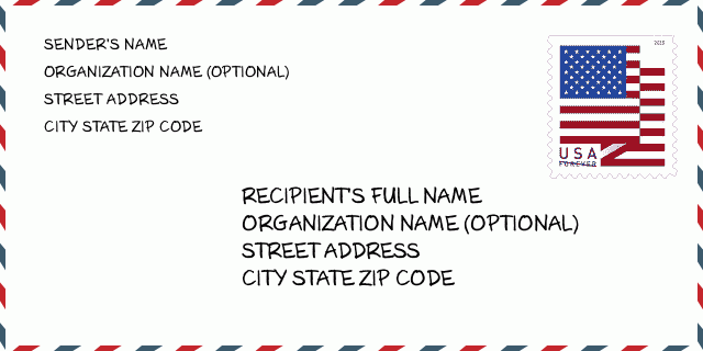
这是美国信封例子。在左上角填写发件人信息,右下角填写收件人信息。必须要填写的信息有发件人和收件人的姓名、街道地址、城市、州还有邮政编码。收件人的地址示例仅供参考。通常来说,如果你不确定九位邮件,你可以仅仅填写五位邮编,以避免邮件丢失。
99501-3229基本含义
-
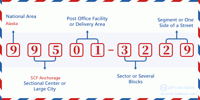
邮政编码 99501-3229 的每个数字代表什么?ZIP+4 Code由两部分组成,前五位数字可以定位到邮局,后四位数字可以确定五位数字递送区域内的一个地理区段。6-7位数字指定区域或几个街区,8-9位数字指定区段或街道的一侧。

- ·运输路线ID?
A 4-digit code assigned to a mail delivery or collection route within a 5-digit ZIP Code. The first character of this identification is alphabetical, and the last three are numeric: Bnnn = PO box Hnnn = Highway contract Rnnn = Rural route Cnnn = City delivery Gnnn = General delivery: C001 (城市投递)
- ·邮递附加低部?
The ZIP Add-On Low Sector and the ZIP Add-On Low Segment together form the ZIP Add-On Low Number. The ZIP Add-On Low Number is the last four positions of a ZIP+4 code; the low-end ZIP add-on in a range of codes; the add-on of the first ZIP+4 code in a consecutive series of ZIP+4 codes assigned to the delivery address. For example, most delivery addresses are assigned a single ZIP+4 code. However, large companies may be given a range of ZIP+4 codes that can be used to route mail to specific departments. A range of ZIP+4 codes can also be assigned to a corresponding range of post office boxes, and each box is mapped, one-to-one, with a ZIP+4 code in the range. A single post office box can also be assigned a range of ZIP+4 codes.: 32
- ·邮递附加低段?
The ZIP Add-On Low Sector and the ZIP Add-On Low Segment together form the ZIP Add-On Low Number. The ZIP Add-On Low Number is the last four positions of a ZIP+4 code; the low-end ZIP add-on in a range of codes; the add-on of the first ZIP+4 code in a consecutive series of ZIP+4 codes assigned to the delivery address. For example, most delivery addresses are assigned a single ZIP+4 code. However, large companies may be given a range of ZIP+4 codes that can be used to route mail to specific departments. A range of ZIP+4 codes can also be assigned to a corresponding range of post office boxes, and each box is mapped, one-to-one, with a ZIP+4 code in the range. A single post office box can also be assigned a range of ZIP+4 codes.: 29
- ·邮递附加高部?
The ZIP Add-On High Sector and the ZIP Add-On High Segment together form the ZIP Add-On High Number, which is the high-end ZIP add-on in a range of codes; the add-on of the last ZIP+4 code in a consecutive series of ZIP+4 codes assigned to the delivery address. Most delivery addresses are assigned a single ZIP+4 code; however, large companies may be given a range of ZIP+4 codes that can be used to route mail to specific departments. A range of ZIP+4 codes can also be assigned to a corresponding range of post office boxes, and each box is mapped, one-to-one, with a ZIP+4 code in the range. A single post office box can also be assigned a range of ZIP+4 codes. (See also ZIP Add-On Code.): 32
- ·邮递附加高段?
The ZIP Add-On High Sector and the ZIP Add-On High Segment together form the ZIP Add-On High Number, which is the high-end ZIP add-on in a range of codes; the add-on of the last ZIP+4 code in a consecutive series of ZIP+4 codes assigned to the delivery address. Most delivery addresses are assigned a single ZIP+4 code; however, large companies may be given a range of ZIP+4 codes that can be used to route mail to specific departments. A range of ZIP+4 codes can also be assigned to a corresponding range of post office boxes, and each box is mapped, one-to-one, with a ZIP+4 code in the range. A single post office box can also be assigned a range of ZIP+4 codes. (See also ZIP Add-On Code.): 29
- ·邮编附加: 3229
- ·范围?
The range of +4 codes. Summing the +4 Code and the +4 Range will give you the high end of the range of +4 Codes that pertain to this ZIP Code.: 0
- ·基本替代代码?
Code that specifies whether a record is a base (preferred) or alternate record. Base records (represented as "B") can represent a range of addresses or an individual address, such as a firm record, while alternate records (represented as "A") are individual delivery points. Government deliveries will only be listed on alternate records with the appropriate government building indicator (federal, state, or city) set.: 基本
- ·财务数字?
A code assigned to Postal Service facilities (primarily post offices) to collect cost and statistical data and compile revenue and expense data. The state number comprises the first two positions of the finance number.: 020312
- ·国会分区数字?
A standard value identifying a geographic area within the United States served by a member of the US House of Representatives or Senate. If Army/Air Force (APO) or fleet post office (FPO), this column will be blank. If there is only one member of Congress within a state, the code will be "AL" (at large).: AL
- ·最后行城市州代码?
An index to the City State file that provides the preferred last-line name for this address range.: Z10014
在线地图

这是地址800 N ST, ANCHORAGE匹配的在线电子地图。您可以使用图中按钮来移动、缩放。该地图信息仅供参考。
地址: 800 (From 800 To 898 Even) N ST, ANCHORAGE, AK 99501-3229, USA
评论


